
Georgia Wilderness Society
Tallapoosa River Alabama
Tripping on the Tallapoosa
June 3-6, 2024
Trip leader Curt Cole
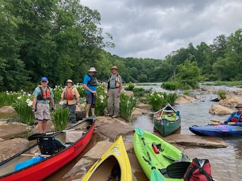
On Tuesday, June 4, 2024, six Georgia Wilderness Society paddlers set off to explore a new section of the Tallapoosa River, in east central Alabama. We’ve paddled various sections of it in Georgia and east Alabama, but this section centered on Horseshoe Bend National Military Park, not far from Alexander City. Most of us arrived Monday afternoon to camp at Wind Creek State Park, one of the largest state parks in the country with 586 sites, most beside the lake (Martin).
Tuesday morning, we put-in at Horseshoe Bend National Military Battlefield (paved parking w/boat ramp) and paddled about 6 miles down to Jay Bird Creek (gravel parking, boat ramp and dock). We passed about 4 stands of the famous shoals lilies, which were in beautiful bloom. We also encountered various class I shoals, some of which were closely spaced, which required some quick moves and on-the-fly route planning. This resulted in one minor capsize that day. We sometimes scraped and briefly hung up, but I don’t think anyone had to get out of their boat to get unstuck. The last ¼ mile was lake paddling or at least a slow current. The Horseshoe gauge was about 3.27’/1,020cfs when we put-in. Our printed guides suggested that below 1,500cfs could present some dragging, but our level was still enough to be enjoyable.
We saw no other paddlers either day, and only a fishing boat at the put-in on day two, but that boat went upstream, so we had the river to ourselves. Very few homes were seen either, although some camps with crude huts or cleared areas were seen. We paddled casually but continuously and reached the take-out after about 3.5 hours, including a half-hour lunch break at a stand of lilies. We capped off the day with a good, cheap meal at Carlos’ Mexican Grill in Alex City, but our campfire got rained out.
Wednesday, we put-in at Germany’s Ferry (paved parking & ramp), and paddled a nearly 10-mile section to Horseshoe Bend. This included Griffin Shoals, a class I+ (II) shoals of a mile or so long, with small ledges, but only one or two stands of lilies. At one point, we drifted for a few minutes as we watched what was likely an osprey, fishing for lunch. It hovered and dived into the water, but appeared to come up empty handed. It was fascinating to watch. We also saw what was likely an immature bald eagle. A muskrat or otter was also reported, but not many turtles or fish. Other than Griffin Shoals, this was mostly a flat-water section.
This section was reported to be more challenging than Tuesday’s section, and three people found it to be a little above their pay grade, resulting in two more boats capsizing, including yours truly, the trip leader. I had a choice of an easy route, which the more cerebral skippers took, or the damn-the-torpedoes-full-speed-ahead route, which seemed to offer a better learning experience. What I learned was that the 2’ or more ledge that my first mate and I attempted is best left to others. Thanks to the faithful GWS members for rescuing the boats that got away, and for towing the remaining boat to shallow water.
This is a dam-controlled river, and the gauge on day two was running 4.25’/2,570cfs at the time we got on the water. Both sections we ran are very wide, so you typically have a choice of which route to take, easy or more challenging. It’s a river that I would
recommend, provided you have some experience in river running, as opposed to lake paddling or a complete novice. Many people recommend a swift, right-side channel in Griffin Shoals, but we found it blocked by a strainer at the entrance. We took about 4 hours, including lunch, to run this second section.
The battle of Horseshoe Bend took place March 27, 1814, with one side, whites and Indian allies, led by General Andrew Jackson, and the other side, the defending Upper Creek Indians, led by Menawa. They had placed a breastwork across the bend to protect their village. After Jackson’s men overran the works and the village, the surviving Indians (800-1,000 were killed on land in the horseshoe) tried to swim or paddled across the river. The last two miles to Horseshoe Bend, we paddled something akin to a graveyard, as during the battle, those Indians attempting to cross the river were shot down in large numbers, over 200 by some accounts. Some died instantly, but the vast majority likely drowned after being wounded. This lost battle resulted in the Creeks ceding over 23 million acres of Georgia & Alabama to the Americans, while the Creeks were eventually given a few acres in Oklahoma.
We had planned to run a third day, from Bibby’s Ferry to Germany’s Ferry, but upon scouting the access points on Monday, I found Bibby’s posted. A call to the sheriff confirmed that the land owner would have trespassers prosecuted, so in the end, and with rain Thursday morning, we all headed home.
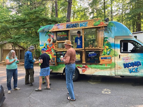
Participants were: Curt & Irene Cole, Joe Mangum, Terry Ross, Jeff Sorensen, and Basil Youman. Thanks to Joe & Jeff for the firewood and shuttles, Terry for the shaved ice from the roaming truck in the camp ground, Irene for the brownies, Joe & Terry for cookies, and all for the fun and participation. Let’s do it again sometime!